

Information
I. General overview 1. Geographical features
Ópályi is situated on the Szatmári Plane, 62 kms north-eastern direction to Nyiregyháza, along the Kraszna river. It is found on road 49 on the way from Mátészalka. The Záhony - Mátészalka trainline crosses here. The climate is between continential temperate warm and cold. The annual sunlight hours is between 1960-1970, the midtemperature is 9 C, 6-9, 7 C, the annual rainfall is between 610-640 mm. The main wind direction is nothern and then comes the southern direction. The forestry's twothird is acacia. Small areas are dominated by aspen, by soft foliage, oak and pine. The soil is mainly field soil and brown forest soil.
2. History
a) village history The village got its name after the estate once owned by Pal the son of Kozma of the Gutkeled noble house that lived around 1289 and also owned Dobos. The surname that is erected from the latin Paulus got the 'i' ending - the possessive pronoun thus meaning Pal's, Paul's possession. The name first appears in 1294. After having different owners it got divided into parts. The Hontpázmány's called Oroszpályi (Orozpauli) , it was deserted at that time. On the Pályi area in 1327 there were two parts within the village. One of the parts had a chapel built for Saint Miklos. The owner of this part was a royal deputy in 1334, and in 1335 he was a witness in János Lengyel's case. In 1337 Egyed's son gave János's part to Dénes Magyar. In 1337 the Rédei's got ownerships and in 1364 the Czudar's received land, at last in 1482 even the Queen. The village from the XV. Century belonged to the Szabolcs county. From the XVIII. Century many families received land , like Telki, Barkóczy, Újfalussy, Ikódi, Bogcha and Izsák. Until the middle of the XIX. century these families were the lairds. At the beginning of the XX. Century Earl Vay, baron Uray and the Teleki families owned bigger parts of the land. In the middleages the residents here were Hungarians, but according to different sources in the part called Oroszpályi slavs that came from the north must have lived here. In the XVI. Century the population decreased, then a new resettlement took place this time romanians. According to resources in the XIX. century a fair amount of foreigners lived here. In the middle of the century Elek Fényes called it a Hungarian - Russian village. On 8th April 1856 the whole village got burned down in a combustion, only the reformed church stayed intact. The church lost all its inventory and registrar. In the middle of the XIX. century 316 reformed and 822 other religious people lived here, According to the 1911-13 gazetteer 541 reformed and 1431 other religious residents lived here. In the 1860 's the village belonged to the Nyiri authorities, from 1870 to the Mátészalka authorities and finally it became part of the suborbs of Mátészalka. At the beginning of the XX. Century it was an individual parish. From 1969 it was the seat of the parish council. Its twin-city was Nyirparasznya, and from the middle of the 1980-s until the 1990-s it was an individual parish council . At the moment it is an individual village.
b) Architectural, cultural inheritage
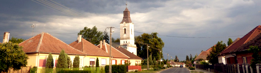
Features: it is situated on the border of the Ecsedi swamp it is a stop-by village, mainly resettled in the middle of the XVIII. Century. The streets are built out long alongside the main road, there are crossings between them. It has narrow , but long parcels the buildings are built in a row or two rows. The houses used to have sand walls , + rooms+ atriums, free chimnies, kitchen, or they had a room + chimney atriums+ room layout. The houses had reed roufs. The ending of the old heating systems resulted in different layouts, roofs. The atriums shrunk into one space, not divided, and a two window front became pitched roofs.They were still using sand for building the walls but adobe was widespread as well. Instead of just painting the walls white outside the wealthier families started decorating their houses outside and started using tiles and slates. The reformed church is from the middle ages and probaly was built out of the old chapel originally made for Saint Miklos. We have no information about the history of the church. But like in the sorrounding villages this church also got reformed they had the first reformed mass in 1617. The church got renovated in 1628,1787,1872,1930, 1970-1972. Its features are a tower roof, quad layout, oriented, on top of a hill. The organ was made by Miklos Váradi in 1941 with 6 diversions. There are 280 seats. The building is an art relic. The greek catholic church was built in 1778 out of wood, the interior design in 1786 was still missing. The parish was already up in 1760. The school was also built in 1782 on the land of earl Haller. The church stands on a hill, it is oriented, and has an arch type baroque fascade.
3. Demographical features
The size of the village is 26,72 km2 the population is 113,96 / per person / km2. The population was decreasing from the 1970-s until 2001. By 2004 it started grandually increasing see chart 17. In 2004 the population was 3045 persons, 1585 female (52%) 1460 male (48%). 28.69 % of the population is young (0-17 years old) , 56,43 % are adults (18-59 years old) and 14.88 % is old ( at least 60 years old). From the age according to the cenzus the education is as follows: 111 persons (4,2% ) has not finished primary school , only has 1-7 classes 834 (31.6%) has finished primary school 756 persons (28,6%). 556 (21,06%) persons finished high school without passing the final exams, 287 persons (10,8%) has got the final exams, 13 persons (0,49%) finished univercity without a diploma , 82 persons (3,1%) got the diploma.
Chart 17. population throughout 1970-2004 Year 1970 1980 1990 2001 2004 Population 2678 2784 2851 2983 3045 Source: (KSH cenzus 2001, KSH T-Star 2004)
4) Population supply, services
a) Education
The kindergarten can accommodate up to 100 children , in 2004 in four classes 96 children attended, there is 9 staff. There is no computer in the kindergarten. In 2004 - 322 pupils studied in the primary school in 22 classes (out of which 38 then attended first class) 82 of them were day-boarders. The number of staff is 31, there is a library, internet access, and 17 computers.
b) health care
There is a GP practise in the village and also a pediatrician, two nurses and a pharmacy. There is no elderly home nor daytime care for them.
c) housing
there are 888 houses in the village out of which 65,3% has running water , 81,4 % has gaz , 42% wireline phone, 35,5 % are connected to the drain system.
d) Shops, restaurants There are 27 small shops, half of them food stores, there is 1 for manifactured goods, 2 clothes shopes and 11 other types. There are 6 restaurants , and a confectionary, 1 bar, wine bar, 1 work buffet. There are private rooms for accommodation at 4 places. There are 198 cars to 1000 people statistically. The village has a train station, an many bus stops. There is a post office too.
5) industry
Employment In 2004 there were 285 unemployeed people registered. (KSH T-Star 2004) which is 16 % out of the population that is able to work (18-59 years old). According to the 2001 cenzus the populations 57,5% work in the service industry in the country. In the building , industrial sector 36,9 % works. 5,7 % works in agriculture .
6) Enterprices
There are 111 enterprices registered in Ópályi out of which 91 is a personal undertaking, 11 of them are limited partnerships and 8 are limited liabily companies.
II. Cycle tracks - possibilities and capabilities
1. cycle path statistics by questionnaire
a) Existing cycle paths. There is no cycle path in the village.
c) the purpose of transportation by bike
residents mainly cycle to school or work. Frequently they use the bike for sorting out everyday tasks like going to the post office, shopping. This is the healthiest way of transport. They are least likely to use bicycles for leasure activities. The bicycle traffic is mainly towards Mátészalka.
d) Cycling Safety
The conditions for safe cycling is lacking at most places. It would be necessary to build out proper cycle paths in order to prevent accident on the busiest streets. Accidents take place mostly on the way between Ópályi and Mátészalka. To make it safer we need to build a separate new cycle path. We should separate cars from cyclists whereever it is possible.
2) Develepment plans for cycly paths
Development should take place whithin and outside the borders of Ópályi. Within the borders it should be Árpád street, Rajk street, Kossuth street and the Narancsliget walkway. Out of the borders between Mátészalka and Ópályi would be the most needed. The planning and implementation of the paths will start later. We would like to finance the implementation from winning different tenders. (UKIG, County Development Board)
Cycle paths are important to make traffic safer within the village, especially at main roads that lead through the village and connect big junctions. It would also make communication easier between surrounding villages, they could be approached easier as well.